Investigating place in Kilburn
December 2023
Having previously shared fieldwork resources for investigating the health of your high street, this follow up blog is about investigating a sense of place. As before, I decided to write this up in response to the Ofsted ‘Getting Our Bearings’ report which highlighted the poor quality of fieldwork in many schools. It remains an area that I know I need to work on…How do you build an effective fieldwork curriculum? How can you move away from the classic (often repetitive) fieldwork foci and ensure it is both engaging and yet effective? How do you make the most of a precious day out of the classroom?
This blog shares the idea, logistics and resources around investigating a sense of place in Kilburn. In spring 2022 our department was lucky enough to work with TFL on this project but the exercise could be easily repeated elsewhere and in a different context. I think it would work particularly well to get students thinking about a sense of place in your local area and what it means to be a ‘place’.
The context of this fieldwork:
I got in touch with TFL regarding the regeneration of the railway arches at Kilburn Station. I had heard about the regeneration project and contacted them to see if there were any opportunities to get our students involved.
TFL came in and led an introductory session before the fieldwork to give us the context of the regeneration project and tell us more about their work. Whilst this was an excellent opportunity for our students and I’m incredibly grateful to TFL, the ideas below could be used elsewhere without the involvement of an external agency.
This day formed 1 of the 4 required fieldwork days at A-Level. Whilst we did not directly focus on (or make reference to) the NEA on this day, I reminded students that they could do something similar if they wished for their coursework.
The inspiration for the investigation
The TFL team took inspiration from the work of @euanmillls, carried out over 10 years ago now. Titled ‘This isn’t f***ing Dalston!’ he undertook a spatial project to look at where the boundaries of Dalston were according to the local community. We did the same for Kilburn.
Whilst this investigation would work anywhere, it worked particularly well in Kilburn as it is not an administrative area: where does Kilburn start and end? Where are the boundaries of Kilburn? Google maps doesn’t help you… look on Google maps and you’ll be somewhere between Cricklewood, South Hampstead, North Maida Vale and Willesden…

What did we do?
Students were introduced to the project in the classroom: they were going to undertake fieldwork to understand what sense of place exists in the areas surrounding Kilburn Arches. Working in groups they were going to conduct an oral survey to find out how members of the public perceived the area.
In groups of 4-5, the students each walked down a different transect- walking in a different direction away from Kilburn station.
Roughly every 200m they stopped and asked people how they would describe where they are- which place were they in?
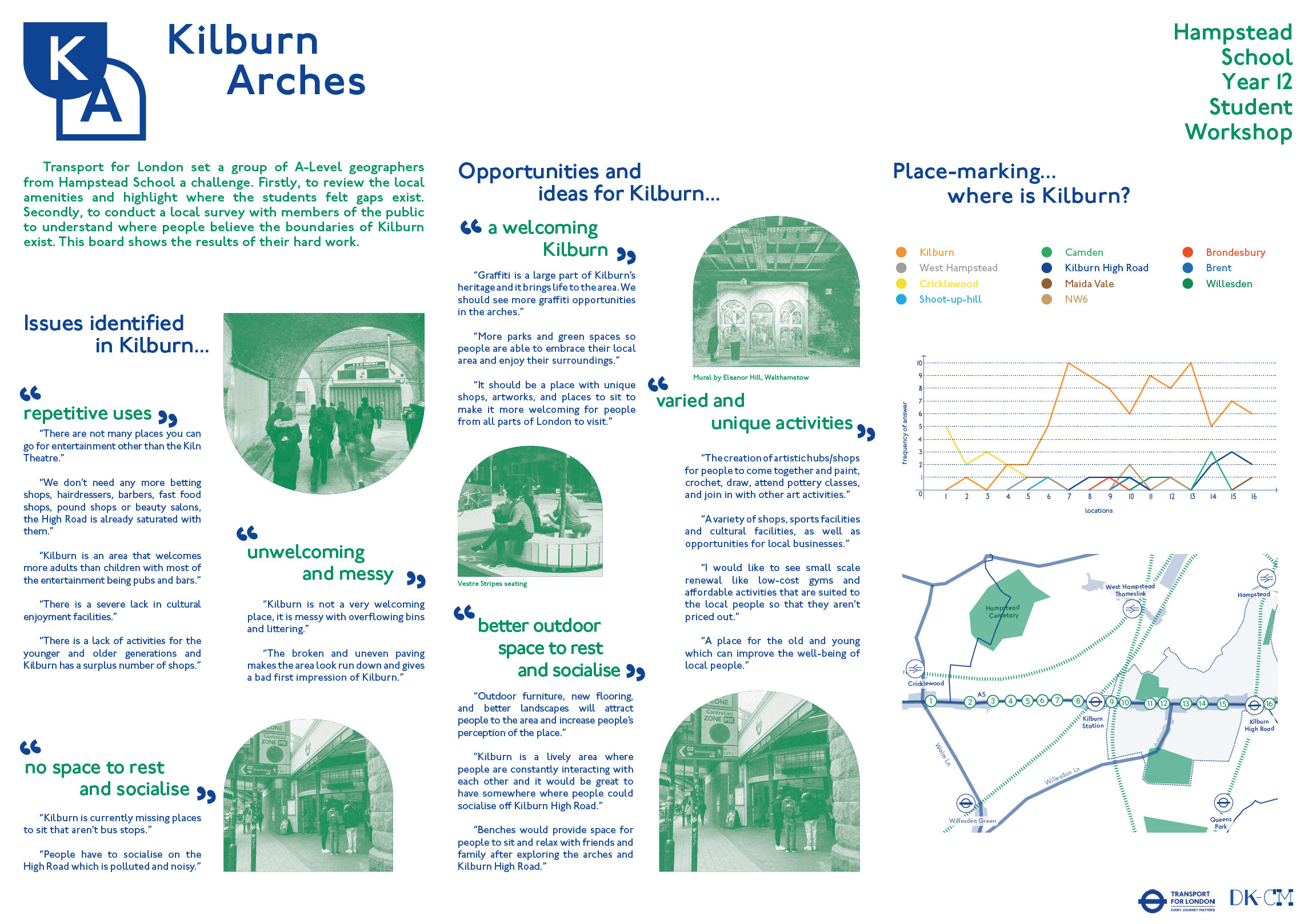
Back in the classroom we crunched the data and used simple line graphs and ArcGIS to locate our data. The results can be seen here.
We tried to draw the boundaries of Kilburn: where did the place of Kilburn start and end according to the community?
I used the following slides to structure their thinking a little as per the fieldwork requirements of Edexcel A-Level. We discussed the risk assessment, ethical considerations, how to conclude and how to evaluate etc.
TFL also took a copy of our results and used it as part of their community engagement work for the regeneration project. This summary was displayed on their exhibition board.
Taking this fieldwork further
If I were to repeat this project, there are several ways I would develop it further:
Use the Time For Geography videos in the introductory lessons to introduce the concept of place to students.
Combine all of our different transects onto one results page using more advanced GIS.
Specifically for Kilburn, draw links to the work of Doreen Massey and her work on place that references the globalisation of Kilburn High Road.
Explore how different mapping software do and don’t refer to the places that we become familiar with. How the place of Kilburn (and it’s boundaries) represented and labelled on Google maps, Bing maps, Strava and other mapping tools?